
Platform
Company
Resources
Blog
Unlocking the Potential of Photogrammetry: Application in Construction Progress Monitoring
Construction site activities are almost always in motion and slow down rarely. Crews rotate in and out, different trades overlap, and tasks change quickly.
But usually, amid this hustle and bustle, some details get overlooked.
Two persons attempting to verify if the installation was done yesterday or not. One is browsing through his images on the phone, the other one is taking a stroll to the site.
In the traditional work methods, this is also more or less normal. Details slip through the cracks. Installations get buried. And when the team needs reliable proof, it is not always available.
This is just the ultimate drawback of having information scattered and mixed up.
But why does it happen? Well, due to the incessant activity on the jobsite.
This is where reality capture technology made its way to the construction site. It provides the field crews with an accurate daily record of progress. That too, without anyone getting slowed down.
Photogrammetry is one of the key instruments used in reality capturing. It has now come to the forefront of progress monitoring.
Want to know more about it? Read on!
What is Photogrammetry
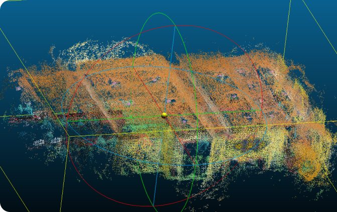
The concept of photogrammetry is quite simple. It measures distance by capturing multiple images of a location and processing them.
Here’s how-
→ You capture photographs (with a 360° camera, drone, or just your smartphone)
→ Put them into a software application and a 3D model appears
→ From this model, you are able to take measurements.
To put it differently, photogrammetry allows you to record the site in the same way you normally do. But, in addition, you will have reliable measurements.
How does it actually work?
Photogrammetry relies on a method known as triangulation. In this, you take at least two different angles to pinpoint the position of objects.
This is the case when two human eyes are used, one for each viewpoint. Eye closing will obstruct the distance perception between the objects. But with both eyes, the perception of depth is very clear.
Similarly, the photogrammetry technique is based on the same principle. But in this case, photos are used instead of the human eye’s sight. The process is outlined in several steps as follows:
- The operator will capture a variety of photographs as they go around the project area.
- The program analyses each picture one by one and crosses the dots that appear in more than one image.
- It compares the changes in the position of these points in the various images.
Then, it finally measures the distance, scales and verticals.
Consequently, a virtual 3D map of the space is formed which is reflective of the actual area around the site. The task does not require any special abilities. All you need is to have enough photos that are clear and overlap.
Why Construction Team are Turning to Photogrammetry
Photogrammetry is becoming popular as it addresses several issues in the construction site.
Measurement with Visual Proof
Traditional field measurements can sometimes be either hasty or not so reliable. The pictures, however, leave behind a recorded evidence which is visual and carries a time stamp on it.
This reduces the misunderstanding between trades as verifying work done becomes easier. It even helps the work teams in detecting problems before they cause rework.
Accelerated and More Convenient Progress Monitoring
The pace of the jobs is fast. The teams always need a method to confirm progress without causing any slowdown. Photogrammetry offers a quick and easy way to take progress documentation. This method is suitable for small, medium, and large projects. All that may be needed is a walk with the camera.
Proper Documentation of Progress
The 3D model provides the team a quick and easy method to evaluate the work done vs. work supposed to be done. The owner knows it, the supervisor knows it, and the subcontractor knows it too. There are no technical barriers.
A Digital Replication of the Site From Natural Pictures
Site teams can travel back in time to any particular stage of the construction once a 3D model is generated. They can find out the location of pipes, see the structure prior to drywall or if a region is ready for inspection.
All this can be done from a distance. Thus, no time is wasted in searching for the answers that are supposed to be easily accessible.
Assistance in Case of Damages, Safety, or Disputes
In case of
– bad weather
– equipment damage
– unforeseen problems
Photogrammetry lets the team capture conditions fast and accurately.
This often helps to avoid disputes because the exact situation is clear from the record.
What Do Industry Numbers Tell Us About Progress Monitoring And Photogrammetry
Reworking in construction is still a primary source of cost. Rework usually makes up 5 to 10% of the total cost of projects as per PlanRadar and GEW-LLC. A few mistakes can lead to extensive delays and thus, very expensive corrections.
The transaction costs can be put down through better documentation. Reality capture is widely in demand in the construction industry.
The global construction reality capture market will reach $19.1 billion by 2033 with a compound annual growth rate of 13.7%. In addition, the market for photogrammetry software is speeding up. Why? Because the industry is moving to better documentation and site data.
Challenges to Keep in Mind
Indeed, photogrammetry is a strong technology. But accuracy can still be impacted by some factors:
- Poor lighting reduces the measurement accuracy.
- Images could get distorted on a windy day or a dusty one
- Low resolution cameras could lead to distorted images
- If the images are not overlapped adequately, it will be difficult to combine them
The majority of these problems can be solved. How? By consistent capture routines and casual awareness of the site environment.
Where is Photogrammetry Is Headed
The future of construction documentation is moving toward real-time understanding of jobsite conditions.
As AI progresses, software will compare the photogrammetry models to design drawings to find missing or wrong works.
The teams will be able to spend less time searching for information. And more time on acting based on the clear insights.
Progress updates will be almost fully automated.
A simple visit to the site could help in the generation of-
→ a complete visual
→ measurable record of the day’s activity.
Bottom Line
Photogrammetry has evolved into an industry standard. It’s now an everyday practical tool used in continuous monitoring and jobsite documentation.
Construction is a complex process. Hundreds of people collaborate on thousands of moving parts. Photogrammetry eliminates confusion in the process. It allows the teams to work beyond speculations to accurate, measurable data.
What’s More?
-It works slong with the already existing tools
-It monitors the progress relability while minimizing the possiblity of rework.
subscribe to our blog
- Benefits
See the advantage of comprehensive and unified site documentation with Track3D

Meet Tim Roberts! Track3D’s Customer Success Manager, bringing years of
Why You Should Watch This webinar? Watch this practical session

Even the best-laid plans on paper don’t always translate cleanly