Drone captures have become a standard part of modern construction projects. But the value isn’t in the capture itself; it’s how that data is used to make decisions.
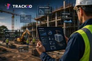
At Track3D, drone data powers a range of project workflows. Teams use orthomaps to check site conditions, compare planned layouts against actual construction using design overlays, monitor facade installation progress, and track project performance over time. Measurement tools extend those same capabilities further, turning drone captures into quantifiable insights that support planning, verification, and reporting.
From cut and fill analysis and grading verification to stockpile tracking and site measurements, Track3D helps teams move beyond simply viewing the site to understanding it quantitatively. The result is better planning, more confident decision-making, and greater control over earthwork operations as projects evolve.
Five tools, built around how sites actually work
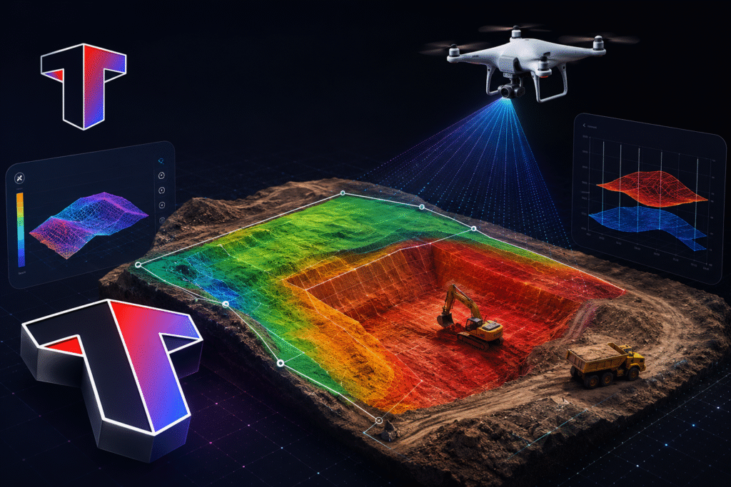
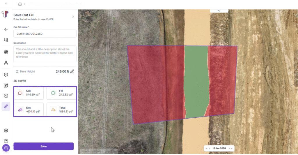
Cut & Fill Analysis for Earthwork Quantity Estimation
Accurate cut and fill quantities are the foundation of grading planning. Knowing how much material needs to be excavated and how much needs to be brought in, before work begins, determines how well material movement, procurement, and site coordination can be planned.
Track3D’s cut and fill analysis compares the existing site surface against a defined target grade, producing a breakdown of excavation and fill quantities across the site. Cut and fill zones are visually separated on the orthomap, so it’s immediately clear which areas are above grade and below grade.
As grading progresses across multiple captures, cut and fill value trends can be tracked over time, giving teams a clear picture of how earthwork quantities are evolving through each stage of the project.
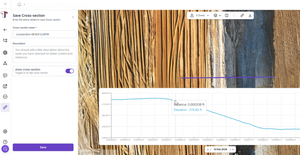
Cross-Section Measurement for Grading Verification
As grading progresses, the next question is whether the work on the ground is forming the way the design is intended.
Cross-section measurement generates an elevation profile along any defined line on the site, showing exactly how the terrain rises and falls across that section. It gives teams a clear view of slope formation, elevation consistency, and grade transitions.
For projects with specific drainage requirements or subgrade tolerances, running cross-section checks during active execution, not just at final inspection, means grading issues get caught while they’re still straightforward to correct.
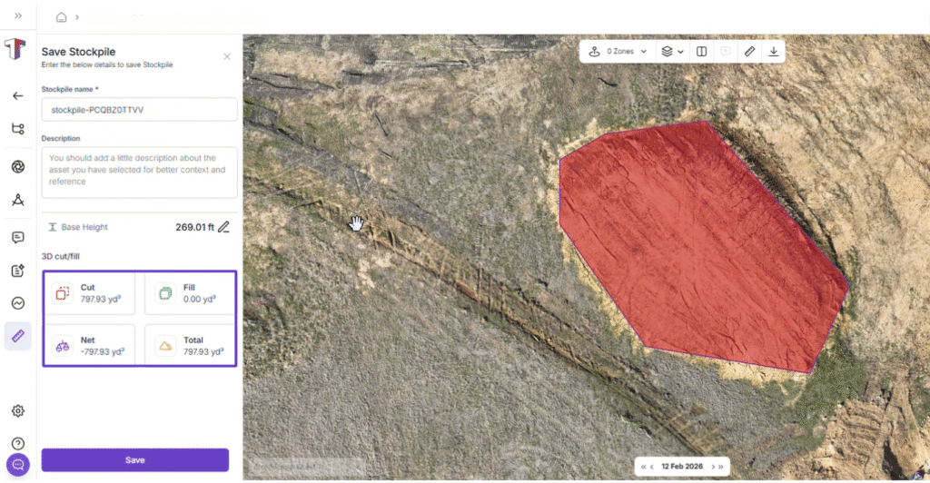
Stockpile Volume for Material Tracking
While grading is progressing, material is constantly moving. Excavated soil, imported fill, and hauled quantities shift significantly between site visits, and without a reliable measurement, it becomes difficult to maintain an accurate view of what’s available on the ground.
Track3D calculates the volume of any defined stockpile area directly from the orthomap, giving teams a measured quantity tied to a specific capture.
It takes the guesswork out of material accounting and gives teams a reliable number to work from when making haul-in, haul-out, and material allocation decisions.
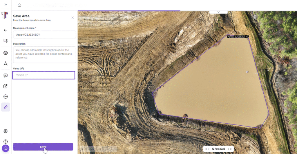
Area and Linear measurement for Site Measurement
Scope definition and layout verification are constant requirements throughout earthwork and into active construction. How large is the excavation zone? What’s the actual paving area? How far is the haul route? These questions need accurate, documented answers that the full project team can reference consistently.
Track3D calculates surface area within any defined boundary on the orthomap, covering excavation zones, slab areas, clearing boundaries, and planned work regions. For distances, it measures between any points on the orthomap, including road lengths, haul routes, pipe runs, utility alignments, and offsets between structures. Both measurements are documented and tied to the current site condition, reducing the need for repeated field visits and keeping planning and execution aligned on the same numbers.
Compare Mode and Measurement Sharing for Progress Reporting
Earthwork evolves across captures and understanding that progression is as important as knowing current site conditions. Track3D allows orthomaps from different dates to be viewed side by side with synchronized navigation. Teams can see how cut and fill zones shifted between captures, how grading advanced between phases, and how site conditions evolved over a specific time period.
Measurements can be kept private for internal review or shared with the relevant project team members when needed.
When documentation needs to go beyond the platform, measurements can be exported as PDF reports. For cut and fill, the report captures how quantities changed across captures, giving teams a clear view of earthwork progress that’s ready for owner reporting, subcontractor coordination, or dispute resolution.
Ground conditions change fast. Having the right measurement at the right time is what keeps earthwork decisions accurate and teams aligned. Track3D’s measurement tools make that possible, directly from the drone captures your project is already generating.