If you’re in the AEC space, you might have already come across the term Reality Capture. It is one of the many technological advancements in the industry that has steadily gained adoption over the past decade.
There’s a lot to unpack when it comes to Reality Capture on how it works, how it helps project teams, why it has replaced traditional construction photo documentation, and most importantly, if Reality Capture is enough on its own.
Let’s dive into all that you need to know about Reality Capture
What is Reality Capture and Why Does It Matter?
Reality Capture Technology
Reality Capture is commonly referred to as site capture or as-built modelling. Regardless of the term used, they all point to the same fundamental capability, which is the process of capturing a jobsite’s physical conditions using various capture methods like 360 cameras, laser scanners, and drones to create an up-to-date 3D digital record of what’s built.
Why Construction Teams Are Adopting Reality Capture
Getting reliable visibility into jobsite conditions has been a real challenge, especially as projects are becoming more complex, with field data often scattered across multiple sources in multiple formats.
This challenge created a need for efficient ways to capture, organize, and understand site conditions in real-time. That’s when Reality Capture emerged, giving teams a consistent and accessible window into what’s happening on site at any given point in time. Ever since, it’s been widely adopted across the industry and here’s why.
- Reduced manual effort: Reality capture mitigates repetitive site walks and the manual effort involved in documenting and sharing jobsite progress.
- Remote jobsite visibility: Owners, project managers, and other stakeholders can review site conditions remotely and reduce the burden of frequent site visits.
- Creates a digital record of the site: Through reality capture, teams can maintain a visual history of site conditions that they can reference for change management, issue tracking, QC, claims, and RFI resolution, etc.
- Earlier Issue Identification: Missed installations, potential delays, discrepancies, and rework can be identified and addressed earlier.
Construction Photo Documentation vs Reality Capture
| Construction Photo Documentation | Reality Capture |
| Periodic snapshots of selected areas or issues that someone notices | Repeatable and systematic 360 capture of the entire site |
| Captured pictures are usually unstructured and spread across different sources | Reality capture software provides a time-stamped, floor-plan-mapped, and geolocated record of the site for every capture |
| Progress comparison relies on manually reviewing the photos | Side-by-side comparison of captures to check progress across various dates |
| In traditional methods of construction photo documentation, the ability to compare site conditions against planned model is limited. | Can easily compare field conditions against the model to identify discrepancies |
| Most of the times, jobsite photos are restricted to the person who captured it | Single source of truth for all the stakeholders involved |
How Does Reality Capture Work on a Jobsite
Reality Capture Workflow
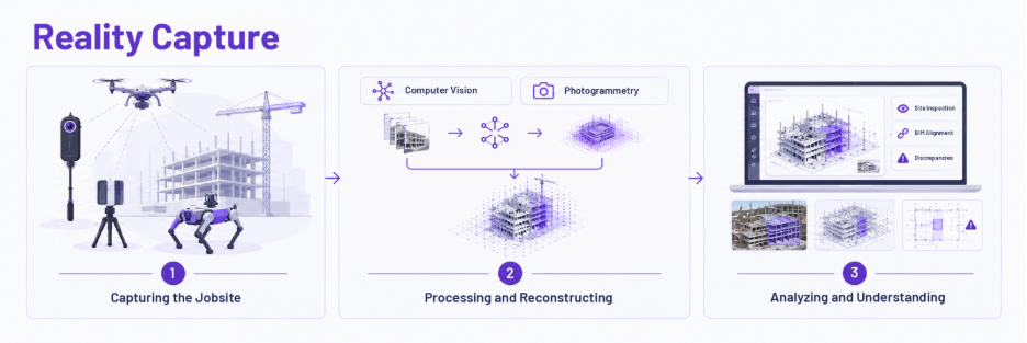
Jobsite Reality Capture typically involves three stages.
- Capturing the jobsite: 360 cameras, drones, and laser scanners are primarily used by construction teams to capture site data. Autonomous drones and robodogs help with collecting data frequently with very minimal human intervention.
- Processing and reconstructing: Reality capture software uses technologies such as computer vision and photogrammetry to process the collected data to create a navigable digital record of the site.
- Analyzing and understanding: The resulting digital jobsite representation can be remotely accessed to inspect site conditions, assess BIM-to-reality alignment, verify progress, and detect discrepancies.
Manual vs Autonomous Reality Capture Methods
| Manual Reality Capture | Autonomous Reality Capture |
| Field personnel actively capture the site with a 360 camera or handheld scanner | Autonomous drones and robodogs follow a predefined path to perform the captures |
| Capture path and coverage decisions are usually made by that field person conducting the walk | The system configures capture routes and coverage decisions, and is not decided in the moment |
| Unlike construction site photo documentation, this is still systematic, but consistency depends on the individual’s schedule | Supports frequent capture intervals and isn’t dependent on staff schedules |
| A practical choice for small-to-medium sites or situations where human judgment is valuable. | Well-suited for large, danger-prone areas where manually walking every day isn’t practical |
What Gets Documented on a Jobsite
As construction moves from site preparation and earthwork ➞ structural ➞ MEP ➞ interiors ➞ closeout, the kind of information worth documenting changes with it.
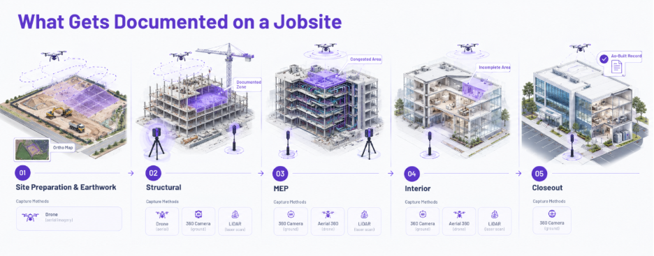
1. Site preparation and earthwork phase
During this phase, drones are generally used to capture aerial imagery across the entire site. Captures should be done by following consistent flight paths and covering the same areas over time so that changes can be identified easily.
This imagery is then further processed into ortho maps and measurable data that can help teams to:
- Track site logistics across haul roads and access routes
- Measure and compare earthwork quantities to verify grading changes, cut and fill, stockpile volumes, areas and distances across the site.
- Spot utility conflicts before excavation to identify areas that need field verification
- Identify erosion and sediment issues by visually reviewing the condition of installed controls
2. Structural Phase
During structural construction, drones, 360 cameras, and terrestrial laser scanners/LiDAR can be used to document entire floors or zones of a building. Important elements to document include foundations, columns, beams, framing, slabs, rebar, embeds, and openings.
This data creates a spatial record of the structure and helps to:
- Supports QA/QC inspections with visual evidence of installed work
- Compare installed structural elements against BIM model
- Compare captures side by side across various dates to check progress
3. MEP Phase
MEP installations can be documented using ground-level 360 cameras, aerial 360 drones (for high-ceiling captures), and laser scanners. Captures should cover MEP routes, ceiling spaces, corridors, risers, shafts, and all the areas where systems are being installed. Frequent captures, along with broader coverage, make it easier to keep up with installations as they progress.
This data can help teams to:
- Document MEP rough ins before the finishes go in
- Review congested areas where multiple MEP systems intersect
- Compare installed elements against the BIM to find discrepancies
- Refer to earlier captures to locate concealed MEP routes when issues arise
4. Interior Phase
For interior work, ground-level 360 cameras, aerial 360 drones (for high-ceiling captures), and laser scanners are used to document the site. Captures should systematically cover rooms, corridors, ceilings, fixtures, and finishes.
This documentation can then be used to:
- Verify room layouts and installed elements against drawings and models
- Remotely review finished spaces to reduce repeated site visits
- Identify incomplete areas before final inspections
- Identify reworks by comparing changes in the same space over time
5. Closeout Phase
During closeout, a few final captures are done using 360 cameras that cover finished rooms, common areas, exterior areas, equipment spaces, and other spaces that are being turned over.
This final data helps teams to:
- Review punch-list items and confirm finished corrections
- Verify final site conditions before owner turnover
- Maintain a complete visual record of as-built conditions for facilities management
For a deeper dive into what gets documented, explore our jobsite documentation guide
Reality Capture Methods
Types of Reality Capture Methods
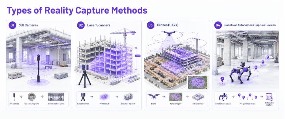
Site conditions can be captured using various sources such as:
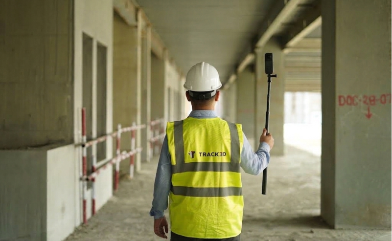
- 360 Cameras: 360 cameras (like Insta360 and Ricoh Theta) capture spherical pictures or videos as someone physically walks through space. This is a cost-effective and standard method of reality capture, as it doesn’t require specialized skill and lets teams document the entire site in minutes, providing comprehensive coverage.
- Laser Scanners: Laser scanners emit laser beams to measure accurate distances across the physical space. Laser scanning is the gold standard for precision used for as-built verification, but it also requires more time and investment than other capture methods.
- Drones (UAVs): Drones fly over a site to capture aerial imagery and videos, covering large sites, roof conditions, facade conditions, and areas that are difficult or unsafe to reach on foot. They help with attaining a bird’s-eye view of the site, making it easier to see the overall layout.
- Robots or Autonomous Capture Devices: Ground Robots, most notably Boston Dynamics’ Spot, follow a programmed path to capture reality data on a set schedule. This reduces the need for repeated manual walkthroughs and is highly useful for navigating hazardous or large environments.
Choosing the Right Reality Capture Method
Choosing the right reality capture method depends on the project size, type, environment, and the level of detail needed. Teams use a different range of reality capture technologies to cover full project requirements.
- Small, Individual Buildings: Most small building documentation can be covered with 360 cameras across multiple floors and zones.
- Commercial, high-rise Buildings: 360 cameras provide broad interior coverage. Laser scanners can complement them when precise geometry, and measurements are required for teams.
- Large Multi-Building Projects: A combination of capture methods is used to cover different parts of a vast site. 360 cameras are used to cover building interiors. Standard drones are useful for capturing site conditions from above, whereas aerial 360 drones are used for capturing interior high-ceiling areas. Along with these, Laser scanners can provide precise spatial data when required.
- Industrial and Manufacturing Facilities: 360 cameras and Laser Scanners work well for capturing industrial projects. These reality capture technologies can document complex layouts, large production areas, equipment, MEP systems, and spatial coordination between them.
- Civil and Infrastructure Projects: For these projects, drones and Laser Scanners are very well suited, as they provide broader coverage along with detailed spatial data.
From Reality Capture to Reality Intelligence
Why Reality Capture Isn’t Enough
Given all this, Reality Capture is a great tool for construction documentation. It answers an important question ‘What does the site look like?
It provides beautiful images of installed walls, ductwork, or flooring and gives teams an organized record of site conditions. This makes it easier to see what the jobsite looked like at any point in time, compare it to models, and visually check what has been installed and changed over time.
But seeing what exists doesn’t necessarily tell you how the project is progressing. Reality capture inherently doesn’t quantify how much work has been installed and whether that work is keeping pace with the plan. For that, teams need objective data into how much work is complete, how much is pending, how that data compares to the plan, and which elements are moving ahead or falling behind.
This is where Reality Intelligence fills that gap and represents the next phase of maturity. Before we dive into Reality Intelligence, it’s essential to understand that reality capture and Reality Intelligence go hand-in-hand. Where the limitations of reality capture arise, Reality Intelligence resolves them.
Moving from Documentation to Decision Making
The main objective of Reality Intelligence is to take the visual data that’s already being collected for reality capture, use artificial intelligence to analyze, measure, and contextualize it, and ultimately generate progress insights that you can work with.
Here’s how we can define Reality Intelligence in a nutshell.
Reality Intelligence = Reality Capture + AI Analysis + Actionable Insights
It’s Reality ‘’Intelligence’’ because it gives you the information and insights beyond documentation and here’s how:
- Automatically identifies all the elements installed without manual review
- Automatically quantifies these installed quantities, such as linear feet installed, cubic yards poured, or square footage completed.
- Detects and flags slowed-down, stalled, and running-ahead elements for better resource management
- Surfaces trade productivity patterns across various captures for faster pay app validation
- Aligns installed quantities with the schedule baseline, so teams see whether pace is tracking to plan or drifting off it
- Compares actual field production rate against required production rate, flagging trades falling behind before the delay materializes
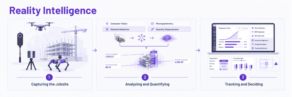
Simply put, if reality capture can provide the answer to ‘What does the site look like? Reality Intelligence can answer, ‘Where does the work actually stand?’ and which areas need attention next?”
To learn how Reality Intelligence can help to keep your projects on track, head here – RI Pillar Article
Choosing the Right Reality Capture Software
To justify the real investment, capturing and organizing site imagery doesn’t suffice. Plenty of reality capture tools on the market can document a jobsite, but the output is almost always limited to a photo archive. When evaluating a solution, it’s worth looking at whether the software can turn the captured data into objective, actionable information that teams can use to keep up with the progress of the jobsite.
A few things to consider:
- Quantified progress tracking: Look for a platform that doesn’t just provide a visual archive but gives you actual installed quantities tied to your drawings and mapped against the schedule. This gives you a holistic view of where work stands.
- Automated Issue Detection: The right solution should automatically flag delays and discrepancies rather than burdening the teams to manually review and identify issues through the captured footage.
- Integration with Existing Tools: Pick a solution that seamlessly connects with your project management systems (like Autodesk, Procore and Fieldwire) to manage key project information.
- Ease of adoption: The platform shouldn’t require a steep learning curve and should be intuitive for field teams to set up projects and start using it quickly.
- Stakeholder-ready reporting: Pick a tool that automatically generates concise progress reports that can be easily shared with owners and project leaders
- Customization as per your workflows: The solution should be flexible and configure around your project needs rather than forcing you into a rigid workflow
Ultimately, the question isn’t whether a solution can make documentation thorough, but whether it can make your decisions easier. A reality capture tool that can comprehensively document your jobsite still requires you to manually piece together information about project status, it hasn’t solved your problem yet.
And the real measure of value here is how quickly and effectively actionable progress insights are provided from the captured data. Track3D’s Reality Intelligence platform, for example, combines jobsite data and project drawings to provide objective progress insights and helps teams to see what’s installed vs not installed, what’s falling behind, how progress compares to plan and where attention is needed.
The results from Track3D’s work on the San Francisco International Airport shows how this approach works in practice.
Case Study: How Hensel Phelps Turned Field Data into Objective Progress
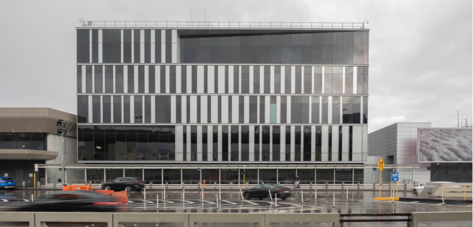
At a six-story office and operations Centre in San Francisco International Airport, the Hensel Phelps team were relying on traditional construction site photo documentation by capturing plenty of data but faced a real challenge in making sense of that data and turning it into a reliable view of progress.
“We were doing what every GC does – walking the floors, taking photos, and marking drawings. We had no shortage of data, but the challenge was turning it into something useful in the moment, without that, it just sat there”
- Garin Anderson, Area Superintendent @HenselPhelps
By using Track3D’s Reality Intelligence, Hensel Phelps turned its existing 360 walkthroughs into objective progress mapped across respective trades, floors and zones. This resulted in the reduction of time-consuming site walks for progress checks and enabled the team to coordinate trades efficiently, faster pay app validation, catch potential delays and reworks earlier.
The results have spoken for themselves.
- 2,964 hours saved
- $342K labor cost savings
- 3 major reworks avoided
- 50%+ reduction in documentation time
- 20+ job walks consolidated
- 26 subcontractors coordinated
The impact here went beyond documentation. Instead of spending hours verifying conditions, the team could quickly see the project status and acted sooner when something needed attention.
We used to spend 20 hours a week just trying to verify progress. Now it’s an hour. We’re not chasing trades anymore; we’re making decisions.
- Garin Anderson, Area Superintendent @HenselPhelps
Click here to read the full version of the case study
Frequently Asked Questions
What is Reality Capture in Construction?
Reality capture is the practice of using tools like 360 cameras, drones and LiDAR scanners to create a digital record of a construction site’s as-built physical conditions at a specific point in time.
How Does Reality Capture Work?
Reality capture begins with construction field teams usually collecting jobsite information with a suitable capture device. This captured data is processed into 360 virtual walkthroughs, aerial maps, and 3D point clouds that help with visually verifying installations and comparing changes over time.
How to use Reality Capture?
Begin by identifying the areas and stages that need to be documented during the key stages of construction with a suitable device. After the imagery and videos are processed by the reality capture software, use the data to take measurements, check installed work, and track issues and QA/QC inspections. The same data also holds up as evidence for disputes, warranty claims, or insurance purposes.
How much does Reality Capture Software cost?
Reality capture software is typically quote-based rather than a flat rate, since cost depends on the square footage of the project. For general contractors, it’s worth looking into what’s included in license, especially related to capture limits, user limits and project limits. Reality capture platforms like Track3D’s VisualTrack offers unlimited captures and users which makes it easier to roll out across the entire project team.